STEP
The Second Tibetan Plateau Scientific Expedition and Research (STEP)
| STEP
Introduction
As the most unique geology-geography-resource-ecology unit, the Tibetan Plateau is a natural lab for research on the earth and life evolution, multi-sphere interaction and human-earth relationship.
In 1970s, China carried out the first large-scale Tibetan Plateau Scientific Expedition and Research (hereinafter referred to as FTEP), which covered an area of 2,570,000 km2 and published 87 monographs and 5 symposiums. FTEP achievements won the first prize of National Natural Science Award and Chen Jiageng Earth Science Award. Key FTEP members Liu Dongsheng, Ye Duzheng and Wu Zhengyi received the Highest Science and Technology Award, and over 40 FTEP members were elected as academicians. FTEP accumulated a myriad of scientific materials, providing vital scientific support for regional socio-economic development and the broader development campaign of the western regions in China.
It has been almost 50 years since the FTEP, during which time both natural and social environments of the Tibetan Plateau have greatly changed. Temperature increase on the Tibetan Plateau is twice as fast as the global average, making the Plateau one of the world's most unpredictable area in aspect of climate change under global warming. Drastic changes of Tibetan Plateau ecological environment and water cycle resulted in glacial recession, permafrost degradation, glacier lake outburst, glacier collapse, grassland degeneration and frequent debris flow, which takes a heavy toll on human living environment and socio-economic development. As the engine of the "Belt and Road" environmental changes, the Tibetan Plateau is highly relevant to the survival and prospect of the over 3 billion people more in the Belt and Road region. As we move into a new era, a systematic roll-out of STEP with priority given to integrated and interdisplinary research, coordinated innovation and technological cooperation will provide significant scientific support for building a green Silk Road, "a beautiful Tibetan Plateau" and "guarding the last pure land on the earth".
The Tibetan Plateau concerns not only the region, but also the country and the world. It is significant not only on the environmental front, but also in the aspects of socio-economic and national development.
STEP will follow the footsteps of FTEP as it addresses the key scientific issue of Tibetan Plateau earth system change. Priority will be given to TP uplift and its resource-environmental effects, TP carrying capacity, Asian Water Tower change and its implications, westerly-monsoon interaction and its impact, optimization of the TP capacity as an ecological buffer, human impact on and adaptation to the environment, and disaster risk reduction. STEP will pay special attention to how environmental process and mechanism have changed over the last 50 years and the implications involved for human society. As it reveals how Tibetan Plateau earth system and environment changes, STEP hopes to strengthen the capacity of Tibetan Plateau as an ecological buffer and provide science-based solutions for the protection of the Asian Water Tower and Tibetan Plateau as an ecological buffer, for the building of Third Pole National Park clusters as well as for the designing of green development pathways.
STEP will build on the legacy of FTEP as it highlights the research theme of change. By looking into how TP environment has changed, STEP intends to estimate and predict future changes. STEP will promote the integration of industry, education and research as it facilitates the transfer and application of scientific advances and data sharing for high-quality economic growth in the region. STEP will also work closely with the broader international community for collaboration on interconnected scientific questions, as part of its efforts to preserve global environment for a community with shared future for mankind. To this end, 10 major scientific expedition and research tasks are set to be carried out. Special expedition teams have been assembled to work in 5 major research areas with 19 key zones in mind.
STEP will give full play to intelligent technologies to reflect the new era. Space-sky-land observation network system, satellites, high-altitude automatic research robots, internet, big data and super computer, all will be integrated and deployed in STEP. Observation will be upgraded from flow mode to long-term stationary mode, from static to dynamic, and from manual to intelligent, making STEP more efficient in advising major infrastructure projects in the region. Meanwhile, STEP will also draw on the international platform of Third Pole Environment (TPE), which allows best-minds from the region and beyond to work together on Third Pole earth system for TP sustainable development, national as well as global ecological progress.
STEP Objectives, Areas and Methods
(I) STEP Objectives, Areas and Methods
The five-year objectives of the STEP: STEP give priority to environmental changes over the last 50 years and their impact on human society, as it reveals how Tibetan Plateau earth system and environment changes, with a view to strengthening the capacity of Tibetan Plateau as an ecological buffer and providing science-based solutions for the protection of the Asian Water Tower and Tibetan Plateau as an ecological buffer, as well as for the building of Third Pole National Park clusters and the designing of green development pathways.
Efforts will be made under the key scientific issue of Tibetan Plateau Earth System changes and their impact, with a focus on high-priority concerns such as environmental and resource effects of the Tibetan Plateau uplift, environmental carrying capacity in the region, Asian Water Tower changes, westerly-monsoon interaction and its impact, impact of anthropogenic activities on environment and human adaptation, and better hazard risk management.
(II) Major research regions and key zones
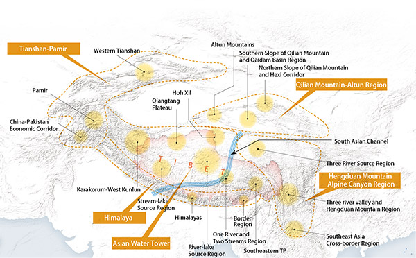
STEP divides the Tibetan Plateau into five major research regions in light of their different environmental, ecological, geological and geographical features and ecological roles.They are the Asian Water Tower Region, Himalaya Region, Hengduan Mountain Alpine Canyon Region, Qilian Mountain-Altyn Region and Tianshan Mountain-Pamir Region. Each major research area is further divided into several key zones. There are 19 key zones in total.

Major research regions and key zones
(III) Observation System and Technical Means of Tibetan Plateau Scientific Expedition
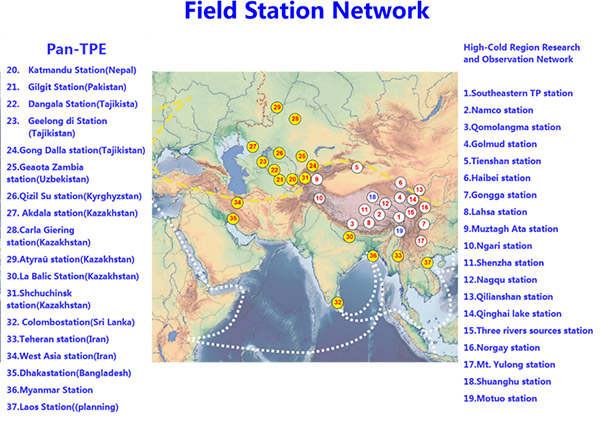
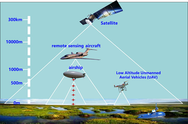
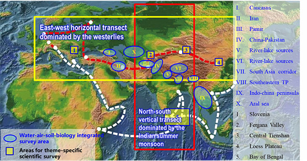
On the Tibetan Plateau, 19 stations have been established by the High-cold region Observation and Research Network for land surface processes &Environment of China (HORN). Outside of China, TPE and Chinese Academy of Sciences have set up 18 flagship stations (Fig. 4). Systematic ground observations have been carried out. Ten stations have been selected for space-sky-land real-time stereoscopic observation using helicopters, mooring powerboats, unmanned aerial vehicles, unmanned vessels, high altitude automatic scientific expedition robots, Internet, big data processing, supercomputing. They are Myanmar Station, Dhaka Station, Kathmandu Station, Southeastern Tibetan Station, Everest Station, Shuanghu Station, Qinghai Lake Station, Muztaga Station, Dushanbe Station and Iran Station (Fig. 5). With that, two observation transects of monsoons and westerly are formed (Fig. 6); STEP will build a Third Pole environmental satellite observation system to monitor the dynamic changes of glaciers, rivers, lakes, forests, grasslands and disasters, which will provide extensive, multi-scale, systematic and accurate data on regular basis for scientific research and socio-economic development. Collaborating closely with Third Pole Environment (TPE) will enable STEP to have top scientists both from the region and beyond to work together for the excellence of Third Pole earth system science.


Introduction
As the most unique geology-geography-resource-ecology unit, the Tibetan Plateau is a natural lab for research on the earth and life evolution, multi-sphere interaction and human-earth relationship.
In 1970s, China carried out the first large-scale Tibetan Plateau Scientific Expedition and Research (hereinafter referred to as FTEP), which covered an area of 2,570,000 km2 and published 87 monographs and 5 symposiums. FTEP achievements won the first prize of National Natural Science Award and Chen Jiageng Earth Science Award. Key FTEP members Liu Dongsheng, Ye Duzheng and Wu Zhengyi received the Highest Science and Technology Award, and over 40 FTEP members were elected as academicians. FTEP accumulated a myriad of scientific materials, providing vital scientific support for regional socio-economic development and the broader development campaign of the western regions in China.
It has been almost 50 years since the FTEP, during which time both natural and social environments of the Tibetan Plateau have greatly changed. Temperature increase on the Tibetan Plateau is twice as fast as the global average, making the Plateau one of the world's most unpredictable area in aspect of climate change under global warming. Drastic changes of Tibetan Plateau ecological environment and water cycle resulted in glacial recession, permafrost degradation, glacier lake outburst, glacier collapse, grassland degeneration and frequent debris flow, which takes a heavy toll on human living environment and socio-economic development. As the engine of the "Belt and Road" environmental changes, the Tibetan Plateau is highly relevant to the survival and prospect of the over 3 billion people more in the Belt and Road region. As we move into a new era, a systematic roll-out of STEP with priority given to integrated and interdisplinary research, coordinated innovation and technological cooperation will provide significant scientific support for building a green Silk Road, "a beautiful Tibetan Plateau" and "guarding the last pure land on the earth".
The Tibetan Plateau concerns not only the region, but also the country and the world. It is significant not only on the environmental front, but also in the aspects of socio-economic and national development.
STEP will follow the footsteps of FTEP as it addresses the key scientific issue of Tibetan Plateau earth system change. Priority will be given to TP uplift and its resource-environmental effects, TP carrying capacity, Asian Water Tower change and its implications, westerly-monsoon interaction and its impact, optimization of the TP capacity as an ecological buffer, human impact on and adaptation to the environment, and disaster risk reduction. STEP will pay special attention to how environmental process and mechanism have changed over the last 50 years and the implications involved for human society. As it reveals how Tibetan Plateau earth system and environment changes, STEP hopes to strengthen the capacity of Tibetan Plateau as an ecological buffer and provide science-based solutions for the protection of the Asian Water Tower and Tibetan Plateau as an ecological buffer, for the building of Third Pole National Park clusters as well as for the designing of green development pathways.
STEP will build on the legacy of FTEP as it highlights the research theme of change. By looking into how TP environment has changed, STEP intends to estimate and predict future changes. STEP will promote the integration of industry, education and research as it facilitates the transfer and application of scientific advances and data sharing for high-quality economic growth in the region. STEP will also work closely with the broader international community for collaboration on interconnected scientific questions, as part of its efforts to preserve global environment for a community with shared future for mankind. To this end, 10 major scientific expedition and research tasks are set to be carried out. Special expedition teams have been assembled to work in 5 major research areas with 19 key zones in mind.
STEP will give full play to intelligent technologies to reflect the new era. Space-sky-land observation network system, satellites, high-altitude automatic research robots, internet, big data and super computer, all will be integrated and deployed in STEP. Observation will be upgraded from flow mode to long-term stationary mode, from static to dynamic, and from manual to intelligent, making STEP more efficient in advising major infrastructure projects in the region. Meanwhile, STEP will also draw on the international platform of Third Pole Environment (TPE), which allows best-minds from the region and beyond to work together on Third Pole earth system for TP sustainable development, national as well as global ecological progress.
STEP Objectives, Areas and Methods
(I) STEP Objectives, Areas and Methods
The five-year objectives of the STEP: STEP give priority to environmental changes over the last 50 years and their impact on human society, as it reveals how Tibetan Plateau earth system and environment changes, with a view to strengthening the capacity of Tibetan Plateau as an ecological buffer and providing science-based solutions for the protection of the Asian Water Tower and Tibetan Plateau as an ecological buffer, as well as for the building of Third Pole National Park clusters and the designing of green development pathways.
Efforts will be made under the key scientific issue of Tibetan Plateau Earth System changes and their impact, with a focus on high-priority concerns such as environmental and resource effects of the Tibetan Plateau uplift, environmental carrying capacity in the region, Asian Water Tower changes, westerly-monsoon interaction and its impact, impact of anthropogenic activities on environment and human adaptation, and better hazard risk management.
(II) Major research regions and key zones
STEP divides the Tibetan Plateau into five major research regions in light of their different environmental, ecological, geological and geographical features and ecological roles.They are the Asian Water Tower Region, Himalaya Region, Hengduan Mountain Alpine Canyon Region, Qilian Mountain-Altyn Region and Tianshan Mountain-Pamir Region. Each major research area is further divided into several key zones. There are 19 key zones in total.

Major research regions and key zones
(III) Observation System and Technical Means of Tibetan Plateau Scientific Expedition
On the Tibetan Plateau, 19 stations have been established by the High-cold region Observation and Research Network for land surface processes &Environment of China (HORN). Outside of China, TPE and Chinese Academy of Sciences have set up 18 flagship stations (Fig. 4). Systematic ground observations have been carried out. Ten stations have been selected for space-sky-land real-time stereoscopic observation using helicopters, mooring powerboats, unmanned aerial vehicles, unmanned vessels, high altitude automatic scientific expedition robots, Internet, big data processing, supercomputing. They are Myanmar Station, Dhaka Station, Kathmandu Station, Southeastern Tibetan Station, Everest Station, Shuanghu Station, Qinghai Lake Station, Muztaga Station, Dushanbe Station and Iran Station (Fig. 5). With that, two observation transects of monsoons and westerly are formed (Fig. 6); STEP will build a Third Pole environmental satellite observation system to monitor the dynamic changes of glaciers, rivers, lakes, forests, grasslands and disasters, which will provide extensive, multi-scale, systematic and accurate data on regular basis for scientific research and socio-economic development. Collaborating closely with Third Pole Environment (TPE) will enable STEP to have top scientists both from the region and beyond to work together for the excellence of Third Pole earth system science.


THIRD POLE ENVIRONMENT(TPE)COPYRIGHT 2014-2021京ICP备05002818号-2
TPE PROGRAM OFFICE 16-3 LINCUI ROAD CHAOYANG DISTRICT BEIJING,P.R.CHINA


